


Pradhir Talukdar (Rega)
Preamble: The United Nations Development Program (UNDP), in a study, said that in 2015 alone, 24.4 million people were displaced and migrated around the world. Of these, 6.57 million people have been displaced due to wars and various armed conflicts in the country. Around 2.25 million people have been uprooted by environmental disasters since 2008. But who cares about the millions of people who are being displaced from their homesteads as a result of development activities like roads, ghats, mines, dams, etc.?
Today I am writing about a report that was made just a year before the completion of the Kaptai Dam in the Chittagong Hill Tracts (CHT). The study, funded by the National Science Foundation, conducted a field-level survey in the CHT of then East Pakistan from September 1960 to June 1961. What will be the reaction of the people of Chakma community to the catastrophe after the construction of Kaptai dam on the Karnafuli river, and what will be their alternative thinking? The study focused on where they would build new settlements after the dam, the decision on how to make a living, and so on. The study was published in Geographical Review in 1963. Associate Professor at Sacramento State College of California, David E. Safar was the lead author of the study.
Fragments of the Past: There is a kind of dual rule system in the CHT. The district is governed by Deputy Commissioner and the whole district is divided into three regional circles consisting of three Circle Chiefs (Rajas/Kings). They are the ones who discharge their functions in their respective Circle by their traditional rule. Circle Chiefs collect an annual tax from each indigenous Jumia family (family of shifting cultivator) for the traditional social justice system and subject to rights over the Jum (shifting cultivation). The Chakma circle is the largest in proportion to the population of the Chakmas. However, its population diversity is less than that of Bohmang and Mong Circles. The Chakmas settled outside the Chakma Circle upstream of the Chengi River in the Mong Circle and even in the Indian state of Tripura.
The aristocratic people of the Chakmas brought the Bengalis of the plains as agricultural laborers. With the rise of farming in the plain lands of the hills, the influx of Bengalis from the plain districts also increased. At first, they actually came as laborers but over time the district administration started giving permission from sharecroppers to take possession of lands gradually.
This was a growing general picture until the partition of the country in 1947. The Bengalis of the plains started operating the markets along rivers of the entire district in the hills. The hillmen (Jummas) of plough cultivator of the river valley depend on the market not only on rice and pulses, but also for all the basic necessities, from clothes, utensils to daos, knives, etc. The Bengalis of the plains drive the vehicles and also make the Jummas a minority even as the non-professional laborers. Almost all the officials and employees of the administration are Bengalis from plains. They are the directors of educational institutions and also teach in Bengali. It should be noted, however, that teachers in rural primary schools are not usually Muslim, maybe Bengali Hindus.
The two peoples- Muslim Bengalis and non-Muslim hillmen (Jummas)- have simply not been able to live comfortably together, because of mutual dislike and fear. The absence of Muslim converts among the hill people shows that a barrier to sympathetic communication exists between them. For most Bengalis, the district is still an alien land, where their stay is only temporary. Officials, policemen, boatmen, traders and coolies may spend much of the year in the Hill Tracts, but their families live in the plains. This intensifies the feeling, common among the hill men, that outsiders are exploiting them.
This was a glimpse into the communal life of the CHT people in the eyes of a European researcher at that time.
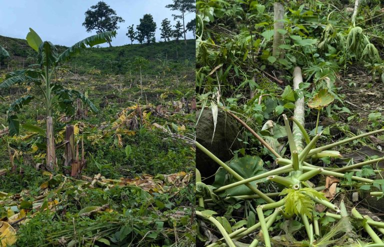
Estimated Data: In 1961, the population of the hill district was only 347,000. In the 1950s, the possible submerged areas of Kaptai Dam (reservoir area) had a population of 115,000, which is about half of the entire district population. About 80,000 people (55%) made a living from plough farming. However, 50,000 of them are classified as people from families dependent mainly on plain/plough farming. The rest are Jum farmers in the hills. It is estimated that the Kaptai Dam, situated 118 feet above sea level, would submerge 225 square miles. With this hydropower project, the target is to generate at least 80,000 KW of electricity in Chittagong region.
Although 80,000 people are expected to be displaced if the area is submerged due to the dam, according to the population register in the late 1960s, the affected population was recorded at 85,300. Of these, 45,500 people, who depend on arable land alone, were estimated to have been directly affected, of which 90% were Jumma people and the remaining 10% were Bengalis. 90% of the Jummas were Chakmas and the rest were Tanchangya and Marma people who live in the middle of the Chengi and Karnafuli valleys or in the Reingkhyong area near Bilaichhari.
According to an official Revenue Department document of 1959, 54,000 acres of arable land would be submerged. Of this, 5,000 acres were cultivable land on a temporary basis. A survey of potential lake areas shows that 32,000 acres of fertile arable land of 39,400 farmers would be submerged, which was 87% land of the area concerned. A survey conducted in February 1970 showed that the 38,000 people dependent on agriculture on just 21,000 acres of land would become evacuees within the district and find a place to live somewhere in the future. The remaining 52,000 evacuees do not know where they would settle. So, it was necessary to make alternative arrangements for them.
The government had promised to rehabilitate everyone with proper land. But honestly no steps were taken to meet that goal. Moreover, there was a lack of awareness among the Chakmas about what would happen after becoming evacuees. As the government was indifferent to the forthcoming problem, similarly, the officials of the administration had a misconception that the backward Jumia Chakmas, accustomed to a nomadic life, could easily survive depending on their nature and Jum. However, the district forest administration strongly objected to the government’s plan to settle in the reserve forest areas of Kassalong and Thega river valley in 1956-57. It was a very insignificant rehabilitation area, but no one in the authorities would admit it. So, it is difficult to decide where the Jummas would go.
Let’s talk about the Kassalong rehabilitation area. It was initially thought that 13,000 acres of land would be available there. Later it was decided to reduce it to 10,000 acres. But in 1960, 8,700 acres of land were given settlement on paper, hence most of the evacuees moved there. Many displaced persons cleaned the deepest forests and built temporary settlements at their convenience. Because it was warned that the place might have to be left if the water level rises even higher. The rumor spread that the area of the lake would be gradually increased by raising the water level after making the height of the dam. So, an uncertainty had to be quietly accepted by the Jumma people during the first settlement. Officially, rehabilitation programs had not been taken into account as much as need. Many of the lands actually available in the rehabilitation area had been settled which were submerged in the lake water during the monsoon season.
Preliminary Choices and Decisions: Let’s leave the common Jumma people of the Chittagong Hill Tracts, even the Headman, Karbari or the local Murubbi (leader) class of the people were in the dark about the possible consequences of the Kaptai Dam. Therefore, after becoming an evacuee, there was a weakness in consulting or making decisions about their future. The Jumma people had a number of choices in making quick decisions in the early 1960s are:
(a) relocation to a higher place within one’s own mouza;
(b) going too far place beyond the potential area of the lake;
(c) moving to the Kassalong rehabilitation area;
(d) making settlement elsewhere in the district or in places in Chengi and Maini valleys not claimed by any other.
The large-scale Kaptai Dam project, funded by the United States, was being overseen by the Revenue Department. The implementation of the project was given more important than the consequences of aftermath of the dam or the rehabilitation of the evacuees. The low-lying lands in the Karnafuli and Kassalang valleys were said to be inundated before the monsoon season of 1960. In order to build a settlement in a new place, the arrangement of primary agriculture had to be made in advance. And the repeated reminding of government Bengali officials to leave their homes and move elsewhere was taken as a kind of pressure by the Jumma people.
So that was the moment before making a hasty decision. Where was it time to go to a new place and build a planned settlement with verifying feasibility in advance? So, the majority of the displaced persons were rushing to move to the place where they decided to go. Most of the affected Chakmas were illiterate. Though emphasis was given to the relocation of Chakmas, but indifferent was seen in relocation of Thanchangyas and Marmas. It was given less important in considering them as a separate population. They were not given the opportunity to rehabilitate or settle in the Kassalong valley. As a result, they are seen to move towards the north side of the Bohmong circle.
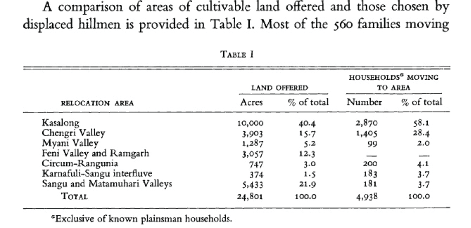
The Muslim Bengalis who became displaced were also considered as separate groups and the district administration took measures to relocate them with more attention. In their case, the attitude of completing the issue of providing compensation to them smoothly is also observed. They were also advised to settle in Shiyalbukya area of Kaukhali and Fasyakhali area of Lama near Chittagong district. Again, the largest number of about 560 families of Muslim Bengalis living in the plain areas were rehabilitated in the Marishya Bazar area towards Kassalang and they settled there on the best lands of 2,000 acres.
Implementation of the Decisions: There was nothing clearly written in the file/document of the district office about what or why decisions had been taken by Kaptai Dam affected Chakmas. There was recorded nothing about official responsibility-based planning or advice or co-operation or supervision in relocating the affected people. The irresponsibility of the authorities was extremely noticeable in the wake of the unorganized migration. In the case of the Chakmas, the documentation of separate (categorized) files was also incomplete. The information about the Bengali evacuees who would be relocated to Kassalang had been sorted out well. The following were the four points mentioned above for the alternative choices of the affected Chakmas:
1) 52% people would be settled at the areas near the lake;
2) 29% people would be shifted to Kassalong area;
3) 14% people would be transferred to Chengi-Maini;
4) 5% people would be settled elsewhere within the district.
However, from the Maini mouth of lower Kassalang to the Karnafuli valley up to Rangamati, the number of evacuees in 6 mouzas was 43%. Out of 8,270 families of Jumma evacuees in 37 mouzas, 1975 families were plough farmers. On the other hand, in the case of mouzas in the Chengi Valley, such as Bakchhari mouza, only 38 per cent of the Chakmas decided to relocate, despite being farmers in 82 per cent of the plain land. From these figures it can be inferred that Chengi Valley was relatively higher than Kassalong Valley. Understanding the plight of Chakma evacuees, concerned government officials also encouraged the Chakmas to relocate as they thought fit.
It was understood that even the government officials were not sure how far the water level of the dam would go. Because it was unknown to everyone about the issue of control the water level of Kaptai Lake even on the difference in the amount of hydropower production. The difference of water level between the dry season and the monsoon season was unknown. The situation might be worsened more than many thought. Again, many did not believe that the water level could go that far/high. Some displaced persons had moved to 40 or 50 feet high in the same area and settled in new locality by building new houses.
This was seen in the case of Subhalong. The people a few miles upstream from Subhalong did not think they would have to be evacuees. Due to the relatively small number of farmers in the plain areas, they thought that they were able to stay as close to the area as possible. And if they had to move, they could make a living by cultivating Jum in the nearby hills. In Kattoli Mouza, only 29% were flat land farmers, but all 380 families had become evacuees and moved to other place. In the case of the Chakmas, Marmas and Thanchangyas of the Reinkhyong and central Chengi valleys, the type of migration was found to be different. The tendency to move to the west and south of Karnafuli was noticeable among the Tanchangyas of Reinkhyong area.
The Chakmas were less interested to migrate to the Mro, Khyang settlements in the south because the region was unfamiliar to them. The Marmas of the two mouzas of central Chengi valley intended to move towards the Marma (Mog) settlement in the Mong Circle. However, the relocation of evacuees had been depended on the availability of alternative land. The land lost by the evacuees in these two mouzas amounts to 21,000 acres. However, expected estimates of the government were much lower/lesser. This difference was arose due to the official calculation of the maximum amount of land lost by each evacuee family as 10 acres. But to compensate for the 21,000 acres, only 15,700 acres of alternative land were found. There is something understandable about this from the information below.
Irresponsible Authority and Leadership Crisis: Settlements along the Indian border in the northern part of the district had been discouraged. Since there had been several recent wars took place between the Pakistani and Indian armed forces. Moreover, the disinterest/reluctance of the Chakmas to settle in the Thega Valley near the international border was also observed. The same attitude could be seen in the Chakma evacuees who had decided to settle in the Chengi Valley. However, the scattered settlement of Tripura Jum farmers already existed in this northern part. Logang Bazaar, the northernmost business center in the Chengi Valley, was established just two decades ago. However, in all these areas, Jum and flat land farming methods were suitable for the settlement of Chakma evacuees. Displaced Chakmas of Kaptai Dam were interested to move in Panchari Bazar area which is situated at an altitude of 200 feet above sea level as there were many Chakma settlements.
Half of the Chakmas who were uprooted in the Chengi Valley were from the lower Chengi area and the other half were from the Karnafuli valley below the Chengi mouth. Therefore, it was considered reasonable for 1,351 displaced families to settle 1,594 acres of land in Panchhari and Logang areas. Of these, 2,309 acres of ownerless land were found to be easier for government officials to rehabilitate in the valley, but only 54 families were registered on the enthusiastic list. In this regard, the explanation of the Chakma evacuees was as follows: “There were various forms of torture by the Pakistani police. They had also been discouraged by reports of smuggling in the border areas, constant extortion by border guards, harassment of Jumma women and possible sporadic firing by India and Pakistan.”
Officially, most attention was paid to the rehabilitation area in the Kassalang Valley. Block-based calculations were planned to rehabilitate the evacuees of each affected mouza in each block. On the basis of the theory of giving land instead of land, the calculation of 10 acres of land per family was also kept in mind. Block leaders were also appointed from the Jumma people. However, for those who had been living in the open plain areas of the river valley for so long, the Kassalang reserve could not be suitable at all. It needed 3 days walk from Rangamati to Marishya. And it took more time to go in a small boat. The market like Marishya Bazaar was built up by clearing the jungle. However, it seemed that the Bengalis had been given priority over the Jumma people in the market area as it was thought that the developing settlement by the Jumma people would be easier than that of the Bengalis.
The Kassalang rehabilitation area was also feared to be submerged during the monsoon season when the water level of the lake rises to its highest level. On the other hand, the forest department officials had warned those who were clearing the forest on the slopes of the hills and developing Jum farming that the land would not be given settlement to them. These uplands had been officially allocated for horticulture. Officially there was no explanation/ instruction of how this land would be used. Such uncertainty was pushing the minds of ordinary uneducated Jumma people towards extreme darkness. Due to the lack of seriousness in the huge rehabilitation process of a large number of incompetent government employees and the aggressive presence of many Bengali peasants, the Chakmas were feeling extremely skeptical and helpless.
In the final stage, the Chakmas feared that their future would have to be built/passed under the authority of the Bengalis, and they were partially pushed into such a situation. While the transferring of displaced peoples by boats for rehabilitation to Kassalang was underway, it was alleged that many domesticated pigs belonging Chakma were being opposed to take in their boats by Bengali sailors. So, in these intolerant situations, many Chakmas had removed themselves from being rehabilitated in Kassalang. On the other hand, they were being pressured to finalize their options for resettlement by February 1960. In such a volatile environment, the lack of proper management and guiding for the thousands of Jumma evacuees uprooted by the Kaptai Dam plunged them into extreme crisis.